Regulation D Rule 506b - Accredited Investors Only
Thrasher #1
Seidler Oil and Gas is an independent energy company focused on oil and natural gas exploration and the development of Salt Water Disposal (SWD) facilities. Our mission is to deliver profitable, diverse investment opportunities through unparalleled service and a commitment to excellence.

Asset Location:
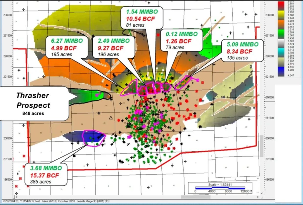
The surface location for the well is situated in Lafourche Parish, Louisiana, specifically targeting the western flank of the Leeville Dome in the Lake Raccourci area. The prospect spans a total of 848 acres (Maximum outline) situated within the highly productive Tex L trend.
Primary Target:
The primary objective lies at approximately ~13,500' TVDSS, zeroing in on the regional Textularia L producer interval—specifically the Leeville North Flank 95 and 96 sands, alongside the PCC/GG/HH sand series in the southwest block.
Structural Trap & Seismic Support:
Thrasher is a clearly defined, fault-bounded trap. Modern seismic evaluation demonstrates powerful hydrocarbon indicators, showing a strong Class IIp / III AVO anomaly featuring a leading negative trough and a potent trailing peak composite amplitude.

Louisiana’s oil and gas sector experienced a significant rebound and regulatory overhaul in 2025, driven by surging natural gas production, major infrastructure milestones, and state tax reforms. State production rebounded as producers capitalized on growing demand for LNG, increased offshore lease sales, and state-level incentives.
Drilling & Production Activity
- Rig Count: Louisiana’s operating rig count has stabilized around 43 active drilling rigs. The split remains heavily weighted toward North Louisiana's Haynesville Shale (holding ~25 active units), alongside minor pullbacks in South Louisiana and a steady offshore count fluctuating up to 13 active rigs.
- Permitting Upswing: Exploration has intensified, with Louisiana issuing 124 drilling permits in the first quarter of 2026 alone. This marks a steep 33.3% increase compared to the same period in 2025.
- Production and Pricing: Elevated commodity pricing continues to incentivize local drilling. The U.S. Energy Information Administration (EIA) estimates natural gas spot prices averaging $4.31/MMBtu for 2026 (a 15.1% increase over Q1 2025). This price strength is driving a projected production growth of 1.2 Bcf/d exclusively out of the Haynesville region.
- Key Operators: Majors such as Expand Energy (formerly Chesapeake), Apex Natural Gas, and Comstock Resources are leading the charge. They are concentrating their newest assets heavily across the Caddo, Bossier, and DeSoto parishes.
Midstream Infrastructure
- Port Arthur Louisiana Connector In-Service: Sempra Infrastructure officially placed its massive Port Arthur Pipeline Louisiana Connector into service. Completed ahead of schedule and under budget, the 72-mile, 42-inch pipeline originates with a crucial compressor facility in Beauregard Parish.
- Direct LNG Supply Expansion: This newly activated connector adds 2.0 Bcf/d of transportation capacity. It acts as a direct feed gas pipeline supplying Phase 1 of the Port Arthur LNG export terminal.
- Egress and Data Center Integration: The combination of newly expanded intrastate pipelines and interstate expansions has solidified Louisiana as the primary swing basin for global LNG export. Operators like Comstock are capitalizing on this by pairing gas production with newly announced, regional gas-fired off-grid power generation to support massive upcoming hyperscaler data centers.
While South Louisiana is historically famous for its thick, highly permeable conventional sands, the strategic deployment of modern stimulation and modern multi-stage hydraulic fracturing has fundamentally redefined the region's recovery economics. Historically, legacy vertical wells in these fairways relied solely on natural reservoir pressure and open-hole completions, which often left significant hydrocarbons trapped in place.
Today, the application of tailored fracturing technology directly to vertical and directional wellbores makes a massive difference in both the initial flow rates and the ultimate cumulative volume a well can produce. By utilizing advanced proppant designs and precisely engineered fracture treatments, operators can aggressively break down tight reservoir barriers, bypass near-wellbore formation damage, and dramatically expand the drainage radius of a single vertical footprint. This technological evolution effectively transforms marginal or dense intervals into highly efficient, high-volume producers, ensuring fast capital payback and maximizing the total recoverable asset value.
Positioned within the prolific Tex L fairway of Lafourche Parish, South Louisiana, the Leeville flank represents a highly strategic, asset-rich frontier for modern independent operators. Long recognized for its historic, multi-million-barrel hydrocarbon yields, this specific region is undergoing a major technological renaissance. The integration of legacy production data with modern 3D seismic, advanced relative impedance amplitude tracking, and precise directional drilling has unlocked premium, unswept structural compartments that rival the economics of the country's core conventional plays.

Seismic-Proven Assets in South Louisiana

Every world-class oil field leaves clues along its margins. In the heart of Louisiana’s proven, oil-prone fairway, the Thrasher Prospect represents a highly defined, premium exploration opportunity targeting an untapped structural fault block on the western flank of the massive Leeville Dome. While the greater Leeville area has historically produced a staggering 96.3 MMBO and 243.2 BCF across all levels, this specific fault block remains entirely untested.
Backed by dense 3D seismic, robust Amplitude Versus Offset (AVO) anomalies, and unmistakable fluid factor support, Thrasher is not a wildcat gamble—it is a surgical offset to multi-million-barrel legacy production. Rincon Energy has mapped a substantial, oil-weighted asset with thick target sands, exceptionally clear analog behavior, and a direct line to Gulf Coast infrastructure, offering incoming partners a high-conviction, fast-payout venture in a proven productive fairway.
Well Plan & Operations
A highly targeted, deviated well path has been designed to launch from a secure surface location and intersect the prospective pay intervals cleanly within the fault block:
- Kick-Off Point (KOP): Vertical drilling down to 10,950' TVD, at which point a 2.0 directional build begins.
- Target Intersections: The well path will intersect the primary North Flank 95 Sand at -13,389' TVDSS (13,541' MD) and the deeper North Flank 97 Sand at -14,377' TVDSS (14,551' MD).
- Proposed Bottom Hole (PBHL): Designed to reach a Total Depth (TD) of 14,500' TVD / 14,682' MD just below the interpreted 97 sand base.

Proven Fairway & Production History
The Thrasher Prospect sits within a heavily digitized, historically prolific Tex L production fairway surrounding the Leeville Dome. The primary structural thesis—that fault-bounded traps along the western flank hold trapped, unswept commercial hydrocarbons—is directly proven by six adjacent, productive fault blocks that have collectively given up 19.19 MMBO and 49.77 BCF.
Modern 3D seismic and relative impedance fluid factor data show that the Thrasher target matches the exact geophysical signatures of these high-rate legacy producers.
Key nearby commercial hits include:
- Texaco SL1908 LPSB #3: Produced 1.15 MMBO and 1.70 BCF from the exact target 95 and 96 sands.
- CNO LL&E #28: Produced 2.94 MMBO and 5.71 BCF out of a nearly identical fault wedge trap configuration.

Target: Unlocking the Leeville Flank
The geological logic for the Thrasher Prospect is backed by a quantitative, risk-adjusted valuation utilizing a Monte Carlo statistical distribution model. Rather than relying on a singular deterministic estimate, this probabilistic framework captures the full range of potential outcomes based on real reservoir variables from the surrounding Leeville field.
The calculations integrate local formation metrics, modeling an average net porosity range of 21% to 27%, water saturation levels between 35% and 45%, and a standard oil formation volume factor of 1.4. The resulting unrisked recoverable reserves yield a highly compelling, oil-prone resource target:
- P90 (Low-Risk Case): Establishes a firm economic baseline of 3.63 MMBO of oil and 7.26 BCF of natural gas. This structural minimum assumes a conservative reservoir footprint of 182 acres and a net pay thickness of 25 feet.
- P50 (Most Likely Case): Represents the primary target case of 6.43 MMBO of oil and 12.90 BCF of gas. This model represents the most statistically probable scenario, tracking an estimated 420-acre structural trap with 50 feet of net pay thickness and a recovery factor parameter of 239 bbl/acre-ft.
- P10 (High-Upside Case): Unlocks an expansive maximum potential of 10.86 MMBO of oil and 21.72 BCF of gas. This case accounts for the maximum mapped structural extent of 848 acres with an optimized net pay thickness of up to 100 feet and a premium 340 bbl/acre-ft recovery factor.
Investment Takeaway:
The seismic attributes at Thrasher show an anomalously negative far-angle amplitude response that directly correlates with the post-3D "unswept" pay responses seen in these core analogs. This indicates that Thrasher is an overlooked, fully insulated compartment containing the same thick, oil-prone sands that drove Leeville's multi-million-barrel legacy success.
Thrasher Far Stack
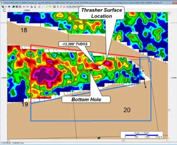
The Thrasher well plan will intersect the target NF95 sands in an area with a good amplitude response.
North Flank 97 Sand Time Structure
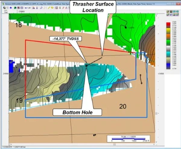
Top North Flank 97 sands Time Structure Map
North Flank 97 sand cut points posted at wells.
The Thrasher well plan will intersect the North Flank 97 sands @ 14,551MD / -14,377’ TVDSS just south of one of the Thrasher bounding faults.
Well Cross Section
The SLCN #10 95 and 96 sands are juxtaposed against upthrown sands to the northwest across the dark blue fault, and against downthrown sands to the southeast across the light blue fault.

Leeville Northeast 95 Sand Analog
Thrasher 2004 Leeville Angle Gathers
Thrasher 2004 Leeville Angle Gathers

The SLCN #10 95 and 96 sands are juxtaposed against upthrown sands to the northwest across the dark blue fault, and against downthrown sands to the southeast across the light blue fault.
Thrasher 2004 Leeville Angle Gathers
Thrasher 2004 Leeville Angle Gathers
Thrasher 2004 Leeville Angle Gathers
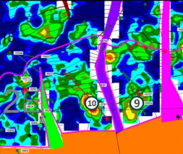
Gathers display anomalous Class IIp / IIIAVO inprospect interval.
Economics and Reserves
Prospective Recoverable Reserves (Unrisked)
Metric Oil Volumes (MMBO) Gas Volumes (BCF)
P90 (Low Case) 3.63 MMBO 7.26 BCF
P50 (Most Likely Case) 6.43 MMBO 12.90 BCF
P10 (High Case) 10.86 MMBO 21.72 BCF
Probability vs. Recoverable Reserves

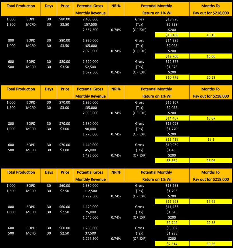
Hypothetical Cash Flow Scenarios